Country Profile
Introduction
The name Zimbabwe is derived from Shona “Dzimba Dzemabwe”, meaning “Houses of Stone” or stone buildings, today symbolized by the Great Zimbabwe near the present-day town of Masvingo. Zimbabwe has a rich history, not only of achievement, innovation, co-operation, and economic prosperity, but also of conflict, trials and tribulations that reflects the dynamism of its peoples. Many scholars, past and present, have enhanced our knowledge of the Zimbabwean past through their works. Particularly important in our understanding of the pre-colonial past have been the works of archaeologists, linguists, historians, oral traditions, and records of 16th century Portuguese traders that interacted with central and southern Africa during that time.
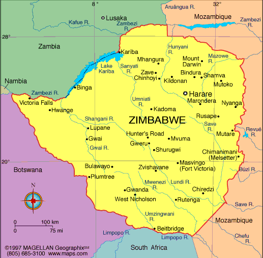
Map of Zimbabwe
The Land
Zimbabwe is situated in south central Africa between the Limpopo and Zambezi rivers, covering an area of slightly above 390,000 square kilometres. Bounded by Zambia to the north and north-west, South Africa to the south, Mozambique to the east and north-east and Botswana to the south-west, Zimbabwe lies wholly to the north of the Tropic of Capricorn. It is part of the plateau, which is a major feature of the geography of southern Africa.
Zimbabwe flag
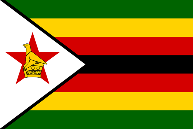
The flag of Zimbabwe consists of seven horizontal stripes of equal width. The middle stripe is black and there are stripes of red, green and yellow above and below the black stripe. On the left side of the Zimbabwe flag is a white horizontal triangle with a red, five-point star in it and on top of the star there is a yellow Great Zimbabwe bird.
- Green: represents the farming and agriculture in Zimbabwe
- Yellow: represents the abundance of mineral wealth in the country
- Red: the blood shed during the first and second Chimurenga (wars of liberation)
- Black: the heritage and ethnicity of the native Africans of Zimbabwe
- White Triangle: symbolises peace in Zimbabwe
- Zimbabwe Bird: the national symbol of Zimbabwe
- Red Star: the nation’s hopes and aspirations for the future
Physical Features
Almost the whole of Zimbabwe lies more than 300m above sea level. Physically, the country is divided by a high central plateau, known as the Highveld, which is about 650 km long by 80 km wide and at least 1,200m above sea level. Most of this predominantly fertile plateau consists of mopane and musasa savannah woodlands. Deep river valleys have split the Middle-veld areas into great blocks of fine plateau country. The Lowveld below 600m comprises a narrow strip in the Zambezi Valley and border tract between the Limpopo and Save rivers. The lowest point in the country is the confluence of the Save and Runde rivers, which is about 162m above the sea level. Massive granite outcrops occur in various parts of Zimbabwe, and along the eastern border is a mountainous region stretching for some 350 km. Towards the north of this region, the country’s highest mountain, Inyangani, stands 2,592 m above sea level and comprises the Vumba and the Chimanimani Mountains at its southern end. The underlying granite, exposed by millions of years of erosion, is seen in its most dramatic form in the Matobo hills, south of Bulawayo.
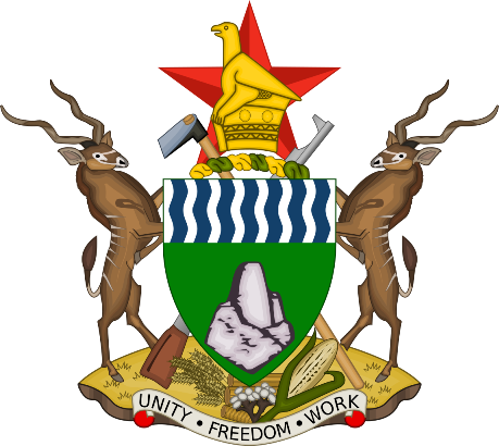
Zimbabwe Coat of Arms

The Coat of Arms depicts two kudus on the left and right, each standing on top of an earthly mound composed of stalks of wheat, a pile of cotton, and a head of maize. At their feet there is also a banner emblazoned with the Zimbabwe national motto (Unity, Freedom, Work). The shield itself is green, featuring 14 waves of alternating white and blue waved lines at top (chief argent), and also at the center of the shield a representation of the ancient Kingdom of Great Zimbabwe is shown. Placed behind the shield are an agricultural hoe (to the left) and an AK-47 automatic rifle (to the right), both of which are tied with twisted strips of green and gold silk. On the crest, the red star and the Great Zimbabwe Bird, which are also depicted in the national flag, are shown.
The meanings of the Zimbabwe Coat of Arms are as follows:
- Kudus: the unity of Zimbabwe’s various ethnic groups
- Earthly Mound: the need to always provide for the Zimbabweans
- Motto Banner: the need to maintain national unity and the preservation of freedom
- Shield: the fertility of the country’s soil and water
- Great Zimbabwe: the historical heritage of the nation
- Hoe and Rifle: Celebrates the struggle for peace and democracy, as well as the proud work-ethic of the Zimbabwean people.
- Strips of Silk: the national financial enterprise and the protection of the economy
- Red Star: hope for the future of Zimbabwe. Conveys the revolutionary nature of the 1980 achievement majority rule, and the struggle towards a fair, equal society.
- Great Zimbabwe Bird: national identity
Climate
Nature has given Zimbabwe one of the finest climates in the world, which is warm without being oppressive and with a daily average sunshine ranging from four to ten hours all year round. Generally, the days are bright and sunny, the nights clear and cool. November to April are the summer months (rainy season) while winter is from May to July and is generally dry. The period August to October is very hot and dry. Both temperature and rainfall are directly influenced by altitude.
The Highveld and the Eastern Highlands have lower temperatures than the Lowveld and the Zambezi basin both in summer and winter. In the latter, summer temperatures can soar to above 35°C compared with Highveld’s average of 25°C to 35°C. Daytime winter temperatures average 13°C to 20°C but can fall to -5°C at night.
Zimbabwe Bird
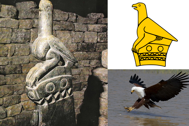
The stone-carved Zimbabwe Bird is a national emblem of Zimbabwe, appearing on the national flags and coats of arms of Zimbabwe , as well as on banknotes and coins such as the Zimbabwean dollar
The People
Zimbabweans have a well-deserved reputation for their friendliness and visitors to the country are assured of a warm and sincere welcome.
Zimbabwe’s population stands at approximately 15 million with an annual growth rate of 3.5%. By far the biggest percentage of the people belongs to the Shona groups who inhabit the north and east, followed by the Ndebele who mainly live in the south-west of the country. Other minority groups include the Batonga, the Venda and Kalanga who live along the south-western borders.
Zimbabwe has sixteen (16) official languages, with English being one of them. Of the two main Bantu-speaking groups; 60% speak Shona and 40% Ndebele.
Land Reform Programme – Resettlement
At independence, Zimbabwe inherited a racially skewed agricultural land ownership pattern where the white large-scale commercial farmers, consisting of less than 1% of the population, occupied 45% of agricultural land. 75% of this is in the high rainfall areas of Zimbabwe, where the potential for agricultural production is high. Equally significantly, 60% of this large-scale commercial land was not merely under-utilised but wholly unutilised.
Agrarian reform in Zimbabwe therefore revolved around land reform where the systematic dispossession and alienation of the land, from the black indigenous people during the period of colonial rule, were adequately addressed. The Zimbabwean Agrarian Reform involved restructuring of access to land, and an overall transformation of the existing farming system, institutions, and structures.
Zimbabwe National Anthem

00:00
Use Up/Down Arrow keys to increase or decrease volume.
Shona
1. Simudzai mureza wedu weZimbabwe
Yakazvarwa nomoto wechimurenga;
Neropa zhinji ramagamba
Tiidzivirire kumhandu dzose;
Ngaikomborerwe nyika yeZimbabwe.
2. Tarisai Zimbabwe nyika yakashongedzwa
Namakomo, nehova, zvinoyevedza
Mvura ngainaye, minda ipe mbesa
Vashandi vatuswe, ruzhinji rugutswe;
Ngaikomborerwe nyika yeZimbabwe.
3. Mwari ropafadzai nyika yeZimbabwe
Nyika yamadzitateguru edu tose;
Kubva Zambezi kusvika Limpopo,
Navatungamiri vave nenduramo;
Ngaikomborerwe nyika yeZimbabwe.
Ndebele
1. Phakamisan iflegi yethu yeZimbabwe
Eyazalwa yimpi yenkululeko;
Legaz’ elinengi lamaqhawe ethu
Silivikele ezithen izonke;
Kalibusisiwe ilizwe leZimbabwe.
2. Khangelan’ iZimbabwe yon’ ihlotshisiwe
Ngezintaba lang’ miful’ ebukekayo,
Izulu kaline, izilimo zande;
Iz’ sebenzi zenam’, abantu basuthe;
Kalibusisiwe ilizwe leZimbabwe.
3. Nkosi busis’ ilizwe lethu leZimbabwe
Ilizwe labokhokho bethu thina sonke;
Kusuk’ eZambezi kusiy’ eLimpopo
Abakhokheli babe lobuqotho;
Kalibusisiwe ilizwe leZimbabwe.
English
1. O lift high the banner, the flag of Zimbabwe,
The symbol of freedom proclaiming victory;
We praise our heroes’ sacrifice,
And vow to keep our land from foes;
And may the Almighty protect and bless our land.
2. O lovely Zimbabwe, so wondrously adorned
With mountains, and rivers cascading, flowing free;
May rain abound, and fertile fields;
May we be fed, our labour blessed;
And may the Almighty protect and bless our land.
3. O God, we beseech Thee to bless our native land;
The land of our fathers bestowed upon us all;
From Zambezi to Limpopo
May leaders be exemplary;
And may the Almighty protect and bless our land.